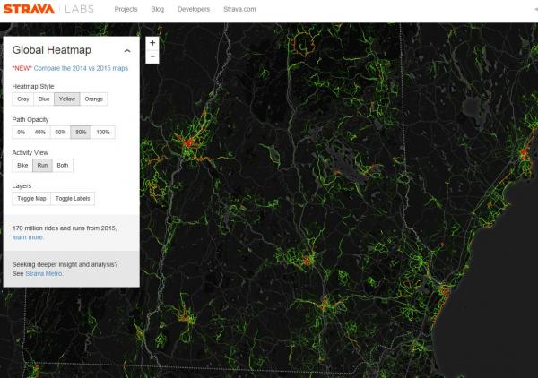
Concord is heating up!! According to STRAVA Labs, Portsmouth, Hanover, and Concordare the brightest spots in New Hampshire followed by Keene and Manchester. We always knew that we are bright and special. These images are according to the runners who run with their phones or gadgets strapped to their bodies and are tech geeks who love data. Well, we love them too because they are shining the way for the most popular loops in town. We can share these hot routes easily using another valuable tracking resource for runners - MapMyRun.com.
Let’s take a closer look at Concord... You might think that Main Streetwould have made the list, but NO! It appears to be an averagely traveled running route for our STRAVA enthusiasts. Our runners tend to travel further off the beaten path and away from shoppers and traffic drawn to shops and restaurants and instead venture onto rolling, forested roads past lakes and ponds.
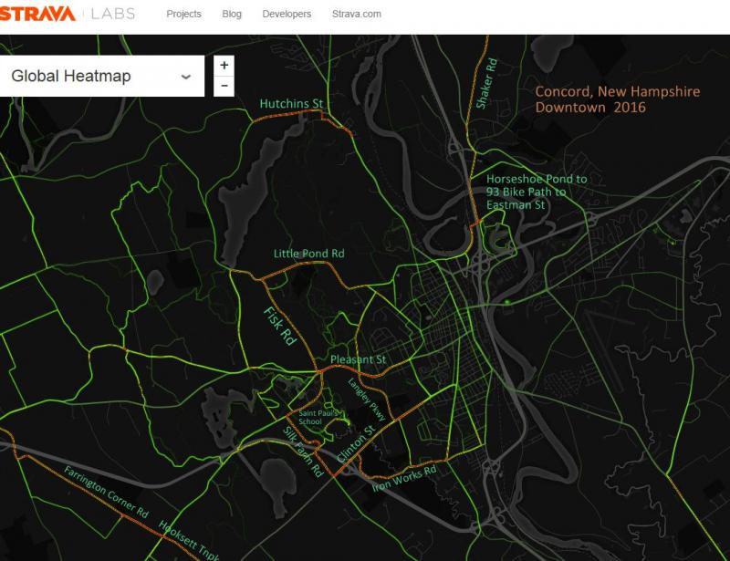
1. Where the Wild Runners are: Silk Farm Loop with an Iron Work’s extension option
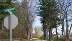
Silk Farm Road is a delightful one mile stretch by itself attracting runners and bicyclists who converge and depart in nearly every direction. It goes from Saint Paul's School Dunbarton Road to Clinton Street. Runners coming from Clinton Street can create a little extension through the Audubon Society's McLean Center trails by following the yellow blazes along the shores of Turkey Pond towards the West End Farm Trail. This takes you to the I-89 bike path. You will likely wave to friendly volunteers who are walking the energetic pups who take up residence at the Pope Memorial SPCA.
Try this 6.5 mile loop
There are so many loop combinations that can be made using Silk Farm Road but it appears that Iron Works Road is a favorite pairing. Begin by parking at the Clinton Street Park & Ride by I-89 and start your run by leaving out of the lot towards the back onto Iron Works Road for 1.3 miles to South Street. Turn left onto South Street for 0.4 miles before turning left onto Conant Drive. Wind through this residential neighborhood on Conant to a right on Norwich Street which takes you to Clinton Street (about 1 mile total). You will stay left on Clinton for only 0.3 miles and then you will turn right onto Langley Parkway to the end (1 mile). Turn left onto Pleasant Street and run for 0.5 miles before entering into Saint Paul’s School Dunbarton Road. Dunbarton will have a gradual uphill through the campus for 0.8 miles where you will then turn left onto Silk Farm Road. Run for another mile to return to Clinton Street. Turn left to go down the hill and under the highway back to the Park & Ride. This entire loop is roughly 6.5 miles.
Create Routes or Search for a route from millions at MapMyRun
2. The Lonely Line: Hutchins and Lake View Drive
Given that there is a lonely line of bright red on the heat map, either we have a Children of the Corn thing going on or many converge and disperse in this area with one commonality: Hutchins Street. This road is often run in conjunction with Fisherville Road towards Beaver Meadow Golf Course or up the West Parish Road massive hills or along the shores of Penacook Lake on Lakeview Drive. Hutchins itself is quite a hill that becomes Lake View Drive which leads to more hills. All that work is certainly not without reward. It is easy to be distracted by Concord's reservoir Penacook Lake peering through deeply wooded forests. The whole road with both Hutchins and Lake View Drive to where it merges onto Carter Hill Road is 2.2 miles one way.
Try this 4 mile super hilly loop
Begin by parking at Carter Hill Apple Orchard. They have a plethora of trails to explore if you want a warm up or change your mind about doing an intense hill combo. If you don't chicken out, begin by turning left onto Carter Hill Road from the orchard and then run for 0.5 miles. Turn right onto West Parish Road and follow that road for about 1.2 miles to the end. Turn right on to Ferin Road for 0.2 miles and then turn right onto Lake View Drive. This is the point where Hutchins gets a new name. After running for just over a mile, you will meet back up with Carter Hill Road where you will take a right to return to the orchard.
Create Routes or Search for a route from millions at MapMyRun
3. Granite State 10
Apparently, we have serious trainers prepping for our October 9th race! Our entire route is glowing red and orange and why wouldn't it be? Ample parking at NHTI, super easy access to the I-93 bike path, a stroll past the Governor's Mansion, and onto a rolling country road equipped with a private school and working farms. There are options to mix in some trails by detouring into the Oak Hill trailhead off of Shaker Road. Check out the course and view the course map here.
Try this 6 mile loop
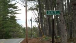
Begin by parking at the Oak Hill Trailhead lot off of Shaker Road. Turn right out of the parking lot onto Shaker Road and run for 0.7 miles before turning left onto Snow Pond Road. Run up the hill for about 0.6 miles and then turn right onto Graham Road and run about 1 mile to the end. Turn right onto Hoit Road and follow for 1.3 miles past the marsh for another 1.3 miles where you will cross over Shaker Road onto School Street then making a quick right onto Hot Hole Pond Road which is another 1.3 miles. You will then meet back up with Shaker Road and take a left to get back to the trailhead parking lot.
Create Routes or Search for a route from millions at MapMyRun
4. A Rollercoaster Combo: Little Pond and Fisk
This loop is super neat so it is no surprise at all that it made the top 5 in Concord by STRAVA runners. There are certainly hills and there are certainly downhills so you will probably want to shorten your stride at times and soak in the scenery. These are country roads with beautiful panoramic views looking out at smaller mountain ranges at times. It seems like every mile or so you will come across intersecting snowmobile trails which navigating these are more like protected secrets held by the locals who are incredibly quick to wave "hello."
Try this 4.7 mile loop
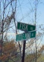
Park at the bottom of Fisk Road at the Winant Park Trailhead. You can opt to add a little by running the trails in Winant Park that parallel Pleasant Street and come out by the hospital or turn left out of the lot down the hill for 0.2 miles to Pleasant Street for another 0.5 miles. At the hospital entrance at Langley Parkway, turn left to enter the Concord Hospital campus up a decent 0.4 mile uphill to the very end where the road turns into a trail. Take the trail and run straight and veer a slight right to stay on the main trail for 0.7 miles where it ends at Auburn Street. Turn left for a quick 0.2 miles before the road veers left and becomes Little Pond Road (affectionately referred to as Rollercoaster Road as you will soon discover why). Continue up the hill and back down to Fisk Road for a total of 1.5 miles then turn left onto Fisk. Fisk will have a surprisingly steep downhill but it will bring you back to your car after 1.2 miles.
Create Routes or Search for a route from millions at MapMyRun
5. Your Ticket out of Town: Hooksett Turnpike to Hopkinton
Should we be taking this personally? What reason could you possibly have for leaving Concord other than Hopkinton and Bow are totally entertaining neighboring towns for runners and bicyclists? Ok.. we understand. Our theory is that this is a common passage for super-athletes since Farrington Corner Road is also illuminated. Half and full marathon runners alike have likely pounded familiar paths through here because the connecting options for getting here usually involve some serious mileage and terrain. Jewett Road and then a left on Route 202 will open up an entire world of gentle country roads and adorable historic towns. Traveling in the other direction across Clinton Street into Bow would send you over some of the most intense hills in the area.
Try this 10 mile lollipop option
Since short loops are not easy to coordinate with this super route unless you have a strong familiarity with the West End Farm Trails, try this intro to the area instead. Park at the I89 bike path trailhead by the Saint Paul's School gate where Silk Farm Road ends for vehicles. Walk back up the road and under the overpass to the narrow bike path on your right and follow for 1.5 miles to the end and then keep going straight onto Stickney Hill Road for another 1.2 miles to a four way intersection where you will turn right onto Farrington Corner Road. Run about 0.5 miles and then turn left onto Brockway Road. Brockway turns for another 1.5 miles before ending onto Jewett Road. Turn right and run for only 0.5 miles before heading right back onto Farrington again. You will stay on Farrington for 2 mostly gentle downhill miles before heading back the way you came on Stickney again to the bike path.
Create Routes or Search for a route from millions at MapMyRun
High five at mile TEN!